Soil & Water Conservation Professional Website Template
Aquifer is a gallery and detail landing page built for aquifer recharge projects. It combines a topographic stats header, a scrollable site gallery with expandable detail panels, and a lead generation form that asks about parcel address, land use, and water concerns. The design uses a pastoral, geological survey aesthetic to build trust site by site.
by Rocket studio
Quick summary
Aquifer is a single-page template designed for conservation initiatives that recharge underground water reserves. It opens with an illustrated stats dashboard, moves through a county-wide gallery of recharge sites, and closes with a lead generation form. The overall feel is calm and credible, like reading a field report from someone who actually knows the land.
Who this template is for
This template is built for people who manage water at a county or regional scale. It speaks the language of drawdown reports, stock ponds, and tap pressure, not marketing dashboards.
- County water managers tracking seasonal water table recovery across multiple sites
- Ranchers and farm operators whose wells or stock ponds have seen declining levels
- Municipal utility planners who need to communicate recharge progress to stakeholders and recruit new partner parcels
What problem this template solves
Aquifer recharge programs often struggle to show results in a way that motivates new partners. Data exists, but it lives in spreadsheets and agency reports that most landowners never read. This template solves that communication gap by putting real site data directly in front of the people who need it most.
- Landowners and planners have no easy way to see what neighboring sites have already achieved
- Complex hydrology data is hard to present without feeling either too technical or too vague
- Lead collection for parcel assessments often happens through generic contact forms that fail to qualify prospects
What you get with this template
The template delivers a complete single-page layout ready to be adapted for any county-level aquifer recharge project. Every section is purposeful and grounded in the project's core goal: convert informed visitors into active partners.
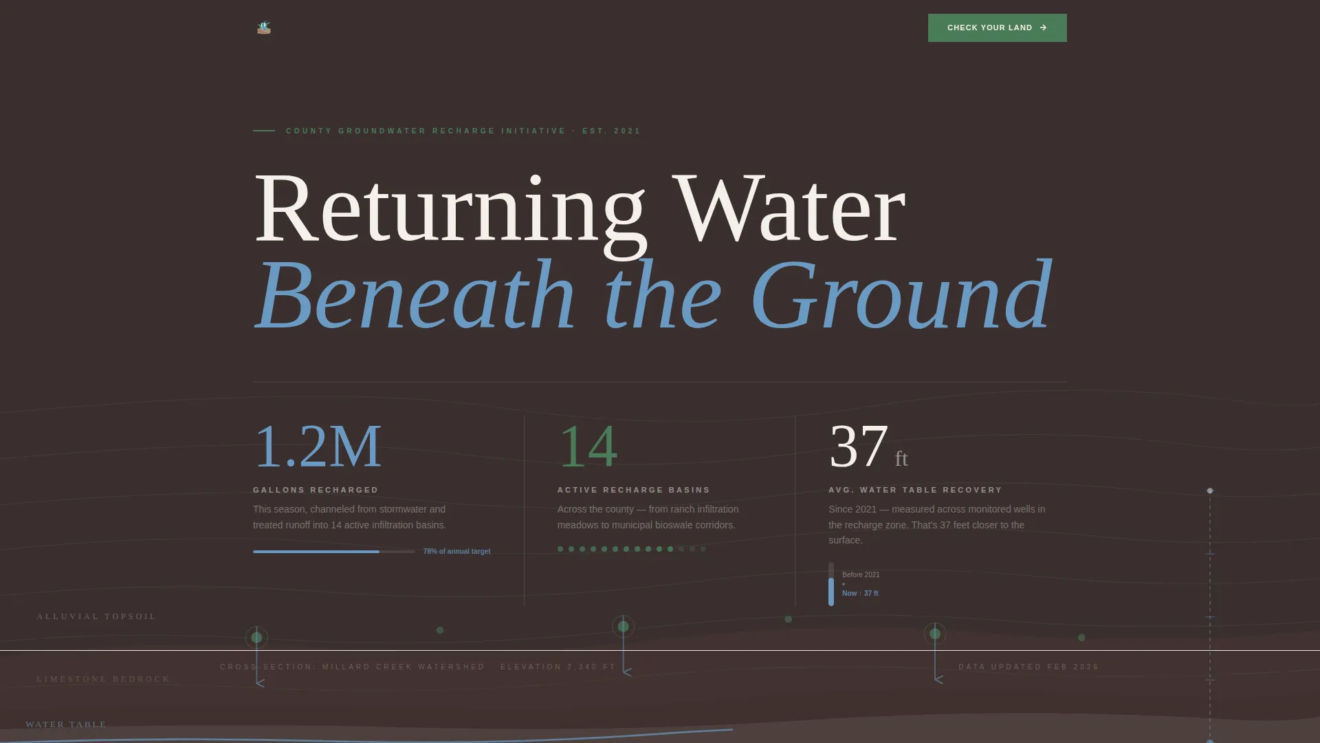
- A topographic hero section with three embedded recharge statistics presented in a hand-drawn illustration style
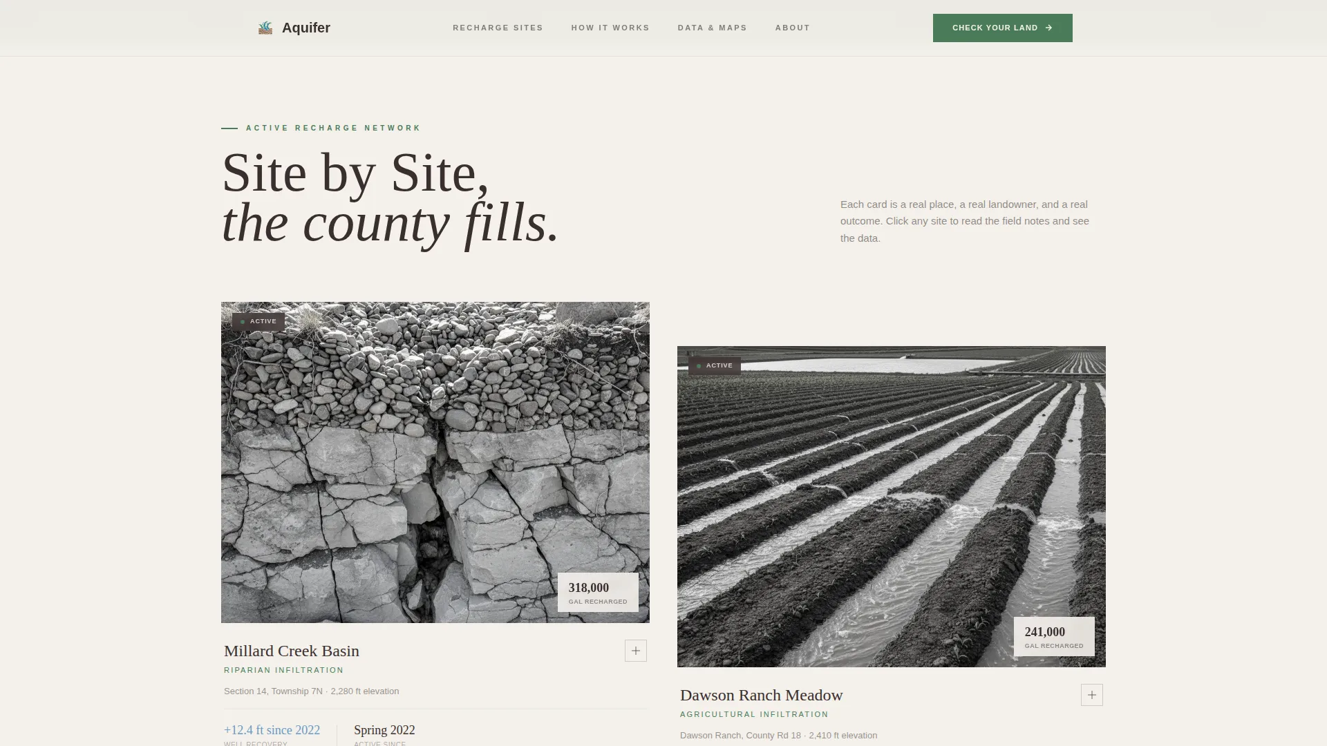
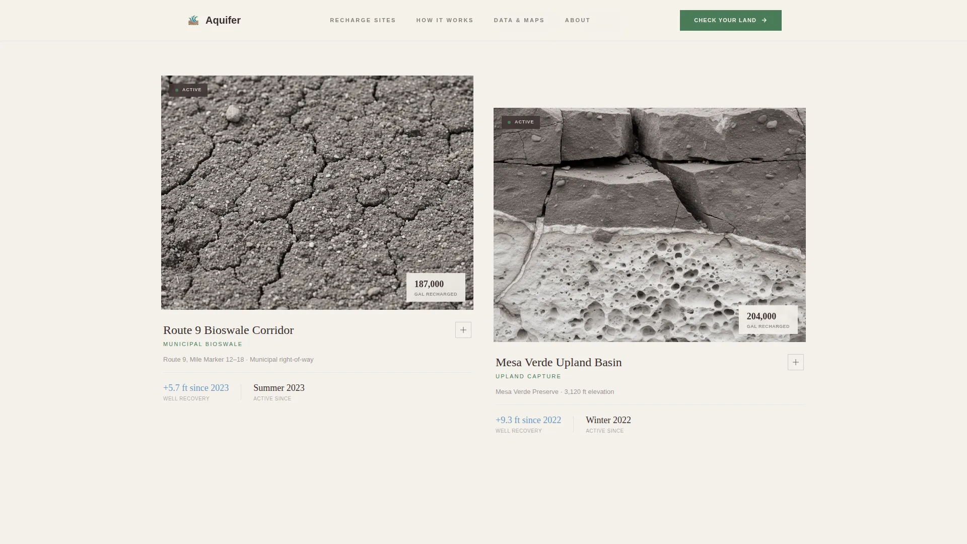
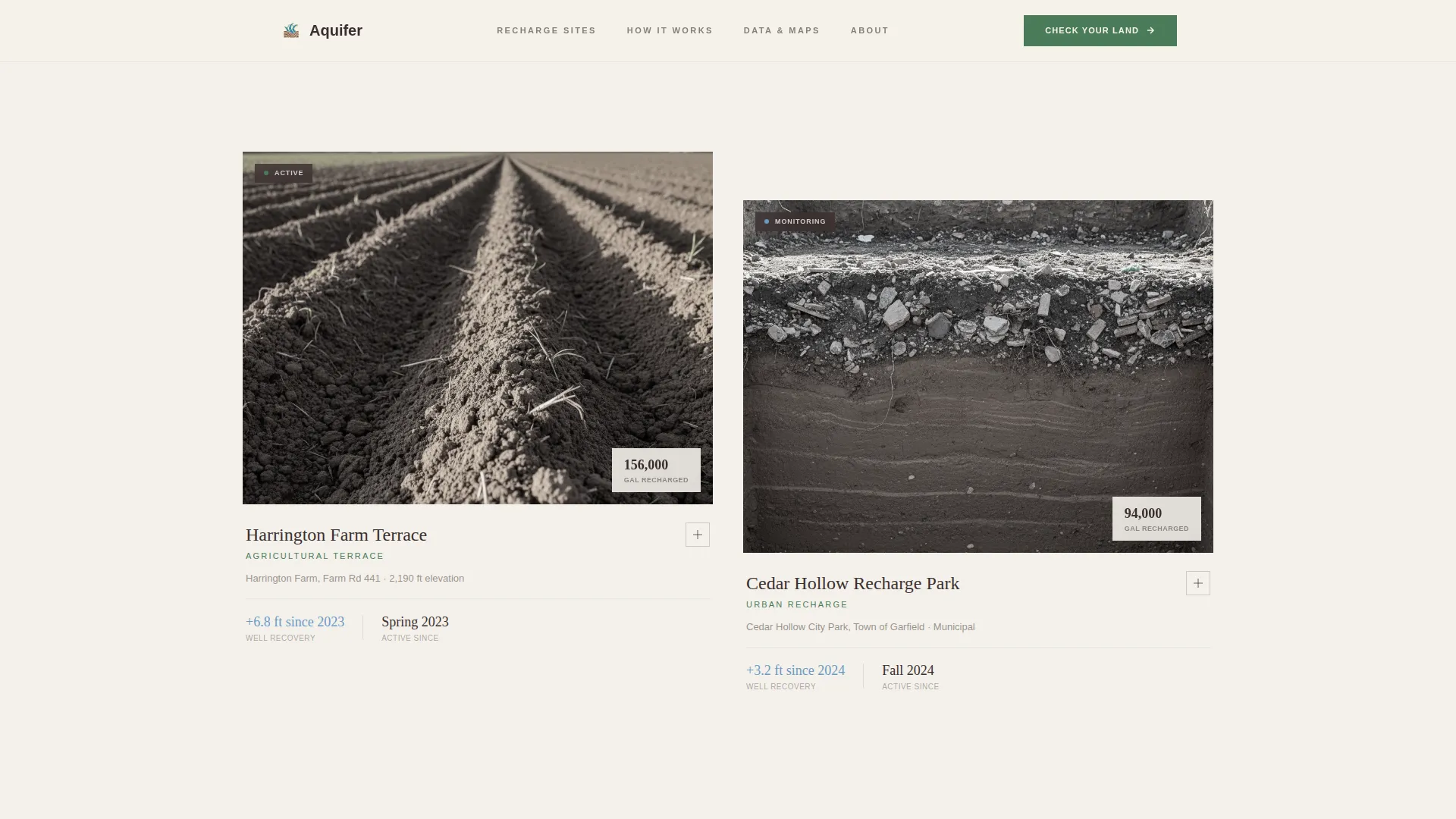
- A scrollable site gallery with clickable cards that expand into full detail panels showing before-and-after views, soil permeability data, and field note copy
- Two lead generation touchpoints: a parcel assessment form and an email-gated county recharge map download
Feature list
This template is built around a specific set of functional and visual components drawn directly from the project brief.
Topographic Stats Hero
The header is a hand-drawn-style cross-section illustration with three live statistics embedded in the terrain. Figures like total gallons recharged, active basin count, and average water table recovery are placed where they appear naturally in a geological diagram. The serif typography gives the numbers the weight of a survey document, not a sales slide.
Scrollable Site Gallery with Detail Panels
The gallery section presents individual recharge sites as cards. Each card shows a real location name and an image. Clicking any card slides open a detail panel containing before-and-after aerial views, soil permeability readings, gallons recharged to date, and a short field note paragraph. The scroll accumulates trust incrementally rather than making a single large claim.
Parcel Assessment Lead Form
After the third gallery site, a lead generation form invites visitors to check their own property's recharge potential. The form collects a parcel address, a land use type selection (ranch, farm, residential, or municipal), and an open text field for the visitor's primary water concern. Form validation is built in.
Email-Gated Map Download
A secondary conversion path offers visitors a downloadable county recharge map. Access is gated behind an email submission, creating a low-commitment entry point for visitors who are not yet ready to submit a full parcel inquiry.
GSAP ScrollTrigger Animations
Section reveals, image overlay wipes, and detail panel slide-ins are handled through GSAP ScrollTrigger. A marquee ticker runs across one section transition. Animations are set to medium intensity so they add rhythm without distracting from the data.
Forest Trust Color System
The four-color palette is applied with structural intent across the layout. Root brown and limestone white alternate as section backgrounds. Canopy green marks transitions between content zones. Stream blue is reserved for interactive elements and data callouts, keeping the visual hierarchy clear and purposeful.
Page sections overview
| Section | Purpose |
|---|---|
| Topographic Stats Hero | Embeds three recharge metrics inside a hand-drawn county cross-section illustration |
| Site Gallery Cards | Displays individual recharge basin cards, each expandable into a full data detail panel |
| Detail Panel View | Shows before-and-after aerials, soil data, gallons recharged, and a field note per site |
| Parcel Assessment Form | Collects address, land use type, and water concern to qualify recharge potential leads |
| County Map Download | Offers a downloadable recharge map behind an email gate as a secondary conversion path |
| Single-Row Footer | Closes the page on a limestone white background with a minimal linear layout |
Design & branding system
The design language draws from geological survey maps and topographic field documents. Every visual choice reinforces the idea that this is serious, place-based conservation work rather than a promotional campaign.
- Four-color Forest Trust palette: root brown (#3B2F2F) and limestone white (#F4F1EB) for backgrounds, canopy green (#4A7C59) for section transitions, and stream blue (#6B9AC4) for interactive elements and data highlights
- Fraunces serif for display headings and embedded statistics; DM Sans for body text and form labels, keeping the reading experience legible and grounded
- Hand-drawn topographic illustration style throughout the hero, with no stock photography anywhere on the page
Mobile & speed optimization
The template is designed desktop-first, reflecting the primary audience of county planners and ranchers who typically work from larger screens. Mobile layout is a solid secondary priority, not an afterthought.
- Responsive fallback layouts ensure the site gallery cards, detail panels, and lead form remain usable on smaller screens
- Server Components handle the static gallery, while Client Components manage interactive panels and the form, keeping the page load lean where it matters most
- Native CSS smooth scroll is used for in-page navigation, avoiding heavy JavaScript dependencies for basic scrolling behavior
How this template helps you convert
The conversion strategy is built into the scroll sequence itself. Visitors are not asked to trust a claim. They are shown evidence first, then invited to act.
- The gallery does the persuading before the form appears. By the time a visitor reaches the parcel assessment form after the third site card, they have already seen real basin names, real recovery numbers, and real field notes from neighboring properties.
- Two distinct conversion paths serve different levels of readiness. Visitors ready to commit can submit a full parcel inquiry. Visitors who want more information first can download the county recharge map with just an email address, keeping them in the funnel without pressure.
Other information about this template
This template sits within the Agriculture and Environment category, under the Soil and Water Conservation subcategory. It is purpose-built for the aquifer recharge project niche and carries an intersection match score of 13, indicating strong alignment between the template's design system, creative direction, and target use case.
- The template style is Gallery and Detail, a format well suited to projects with multiple completed sites that benefit from individual documentation
- The creative direction follows a Local and Neighborhood approach, meaning the content accumulates credibility through familiar, place-specific details rather than broad environmental messaging
- Imperial units (gallons and feet) are used throughout, and the geographic framing is county-level, making it appropriate for United States-based conservation programs
- The header concept is Stats and Metrics, rendered as an illustrated landscape rather than a data table, which keeps the opening section engaging for non-technical visitors
- The landing page direction is Lead Generation, with both a high-intent parcel form and a lower-commitment email gate working together to capture prospects at different stages
Theme
Pastoral Calm
Creative direction
Local & Neighborhood
Color system
Forest Trust
Style
Gallery + Detail
Direction
Lead Generation
Page Sections
Topographic Stats Hero with Embedded Metrics
Site Gallery with Expandable Detail Panels
Parcel Assessment Lead Generation Form
Email-gated County Recharge Map Download
GSAP Scrolltrigger Reveals and Animations
Forest Trust Four-color Design System
Related questions
Who is this template designed for?
Can I add or remove recharge site cards from the gallery?
What does the parcel assessment form collect from visitors?
Is the county map download separate from the main lead form?
Does this template use stock photography?


