Farm & Ranch Appraisal Landing Page Template
Parcel is a dark, map-driven landing page template built for farm and ranch appraisal firms. Its asymmetric 60/40 grid moves visitors through soil, water, and comparable sales content with the confidence of a seasoned field appraiser. An interactive satellite map, sticky lead-capture bar, and gated PDF path turn serious property owners into qualified inquiries.
by Rocket studio
Quick summary
Parcel is a single-page, lead generation template designed for farm and ranch appraisal professionals. It uses a Dark Immersive Navy Authority visual identity, an asymmetric 60/40 grid, and a spatial scroll flow that mirrors walking a property from boundary to boundary. Every section builds credibility through soil data, water rights, and methodology before asking for a contact.
Who this template is for
This template was built for small appraisal firms that work agricultural land. It speaks directly to the professionals who need credibility before the phone ever rings.
- Two-person or small-team farm and ranch appraisal firms
- Independent appraisers serving ag lenders, estate attorneys, and landowners contesting tax assessments
- Appraisal practices that rely on documentation, soil maps, and comparable sales to defend valuations
What problem this template solves
Most appraisal firm websites look like they were built for residential real estate agents. They use stock photography, vague service lists, and no evidence that the appraiser understands the land. Parcel solves the trust gap before a single word is read.
- Replaces generic imagery with a dark satellite parcel map that functions as a live credential
- Guides visitors through soil classification, water rights, and methodology in a logical scroll order
- Captures leads at two stages: those ready to request a review, and those still learning the process
What you get with this template
The template delivers a fully structured, single-column lead generation landing page built around the asymmetric 60/40 grid. Each section alternates dominance so neither column feels static.
- An interactive header map with pulsing pins that reveal acreage, land class, and appraisal type on hover
- A sticky lead-capture bar with a three-field form: county and state, estimated acreage, and appraisal purpose dropdown
- A gated secondary path offering a downloadable PDF guide, captured behind a single email field
Feature list
This section outlines the core designed-in capabilities delivered by the Parcel template.
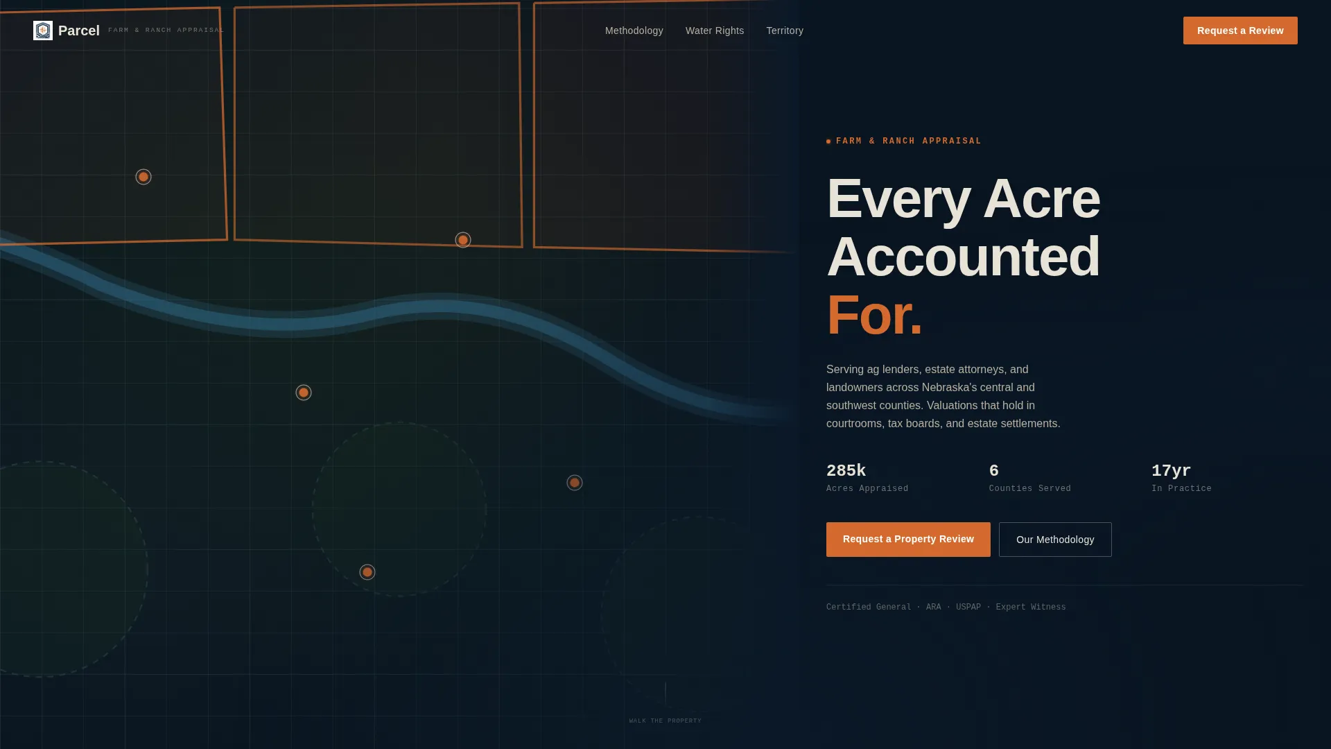
Interactive Satellite Map Header
The 60-column header holds a dark satellite-view parcel map. Property boundaries are drawn in survey-stake orange, pivot circles are visible, and riparian corridors appear in muted blue. Numbered pins mark recent appraisal locations across three or four counties. Pins pulse on hover and reveal acreage, land class, and appraisal type.
Alternating 60/40 Grid Sections
Each content section below the header flips column dominance. One section gives the wide column to a soil classification breakdown with United States Department of Agriculture land-class Roman numerals and per-acre value ranges. The next gives the wide column to water rights content. This alternating rhythm keeps the layout visually active without relying on decorative imagery.
Sticky Lead Capture Bar
A sticky bar appears after the visitor passes the second section. It holds the primary call to action, "Request a Property Review," styled in survey-stake orange. The form collects three fields in sequence and includes a dropdown for appraisal purpose: estate settlement, lending, tax protest, purchase or sale, and conservation easement.
Gated PDF Secondary Path
A secondary conversion path offers a downloadable guide to agricultural land valuation. It is gated behind a single email field. This captures visitors who are still researching the process before committing to a full appraisal request.
Parallax Scroll Transitions
Slow parallax shifts between sections simulate the experience of moving from one pasture gate to the next. The scroll deepens from soil to water to improvements to comparable sales methodology. Each section builds the cumulative case that this firm sees what automated valuation models miss.
Dark Immersive Color System
The entire page uses a Navy Authority palette: deep command navy for primary backgrounds, steel fence-post gray for secondary panels and dividers, parchment white for body text, and survey-stake orange reserved strictly for calls to action, interactive map pins, and hover states.
Page sections overview
| Section | Purpose |
|---|---|
| Header Map Panel | Displays interactive satellite parcel map with hover pins and firm headline |
| Soil Classification Section | Breaks down USDA land classes with per-acre value ranges and narrow explanatory column |
| Water Rights Section | Unpacks appropriation doctrine, well permits, and surface water access with document photograph |
| Improvements & Methodology | Builds the case that field observation captures what automated models miss |
| Comparable Sales Section | Presents the firm's research methodology for finding sales others overlook |
| Sticky Lead Bar | Anchors the primary three-field form after the second content section |
| PDF Lead Capture | Offers downloadable valuation guide gated behind email field |
Design & branding system
The visual identity was built to feel authoritative and land-heavy. It draws from the atmosphere of reviewing aerial photographs in a dim county records office.
- Navy Authority palette: deep command navy (#0B1929) for primary backgrounds, steel fence-post gray (#3A4A5C) for secondary panels, parchment white (#E8E2D6) for body text, and survey-stake orange (#D46A2E) for calls to action and interactive elements
- No stock photography anywhere on the page; the satellite map and document photograph carry all visual credibility
- Survey-stake orange is used strictly for calls to action, hover states, and interactive map pins to preserve its signal value
Mobile & speed optimization
The template is structured for clean rendering across screen sizes. The 60/40 asymmetric grid and parallax transitions are designed to adapt without breaking the spatial scroll narrative.
- Sticky lead bar and three-field form remain accessible on smaller screens throughout the scroll
- Parallax section transitions are built to be lightweight so the immersive effect does not slow the page experience
- The satellite map header scales to maintain readability of boundary lines and hover pin details on mobile viewports
How this template helps you convert
Parcel earns trust section by section before it asks for anything. By the time a visitor reaches the sticky bar, the page has already walked them through soil data, water rights, and methodology.
- The interactive map headline replaces a generic hero with a working credential, establishing expertise before the first paragraph is read
- The sticky lead form appears only after two content sections, reducing friction by letting visitors absorb the firm's rigor first
- The gated PDF captures a second tier of leads who need education before committing, so no serious prospect leaves without a follow-up path
Other information about this template
Parcel sits at the intersection of Farm and Ranch Real Estate and professional appraisal services. It was designed for a niche where trust is built on documentation, not design flourishes.
- The template style is Asymmetric Grid (60/40), with a Dark Immersive theme and a Spatial and Architectural creative direction
- The header concept is Map-Based, meaning the satellite parcel map functions as both a visual anchor and a proof-of-expertise element
- The landing page direction is Lead Generation, with two distinct capture paths for different stages of buyer readiness
- This template suits appraisal firms operating across multi-county agricultural territories where soil class, water rights, and comparable sales drive valuation


Theme
Dark Immersive
Creative direction
Spatial & Architectural
Color system
Navy Authority
Style
Asymmetric Grid (60/40)
Direction
Lead Generation
Page Sections
Interactive Satellite Map Header
Alternating 60/40 Grid Layout
Sticky Three-field Lead Bar
Gated PDF Secondary Path
Parallax Section Transitions
Related questions
Who is this template designed for?
Can I adapt the appraisal purpose dropdown to match my services?
Does the template include the satellite map imagery?
How does the gated PDF lead path work?
Is this template suitable for a solo appraiser?


